Note
Traffic information is not available in all areas/countries.
Coverage areas for traffic information is continuously extended.
It is possible to make settings to determine which traffic-related information is shown on the map.
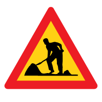
Traffic disruptions, such as congested and slow-moving traffic, road work and accidents, are shown with different symbols when the map is zoomed in.

Road construction, for example, is indicated by this symbol. Sections of road with major traffic disruptions are also shown with a red line on the side of the road affected. The line also indicates which direction of traffic is affected. If the disruption affects both directions of traffic, the section of road is marked with red lines on both sides of the road.
Information on traffic disruptions
Avoiding traffic disruptions
If there are traffic disruptions along the route, the Avoid option can be selected. The system will then calculate an alternate route.
Real Time Traffic Information (RTTI)1
If the vehicle is connected to the Internet, enhanced traffic information can be retrieved using RTTI2.